Vertis Consulting
  • Home
  • About Us
  • Clients
    • Builders/Developers
    • General Contractors
    • Subcontractors
    • Investors
    • HOA's/Property Managers
    • Engineers/Consultants
    • Cole Residence
  • Services
    • Construction Management
    • Estimating, Budgeting & Bid Administration
    • Project Management & Consulting
    • Bond Exoneration
    • GPS Topographical Maps
    • Quantity Takeoffs
    • GPS Modeling
    • Plan Review & Value Engineering
    • Onsite & Offsite Purchasing
    • Cut/Fill Maps
    • Due Diligence
    • Material Import & Export
    • Home Quality Assurance
    • Design Renderings
    • Design Consulting
  • Testimonials
  • Contact Us

GPS Topographical Maps

Picture
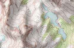
Using the latest global positioning technology, we can provide a topography map of the existing terrain of your project. And the best news is that we can complete it faster and cheaper than anyone else. The Vertis GPS Topo service is best suited for those who need a current topography map for a development site. This helps reduce the chance of change orders and gives you a more accurate estimate of materials needed to complete the excavation phase of your project.


Vertis will also provide daily topography maps during the grading process so you can monitor grading efficiency against cost. You will receive reports and maps every week logging the exact amount of earth moved by the grader.  This helps you monitor the project so you can ensure you will finish on budget and on time.